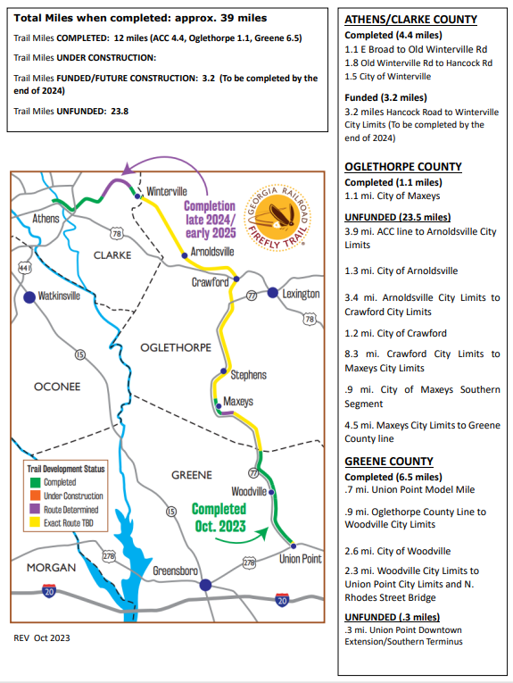
FIREFLY TRAIL PROGRESS MAP
Parking:
Athens-Clarke County and Winterville
Maxeys (City Hall or the Maxeys Community Center)
Union Point (Downtown or at the Firefly Trail Bridge)
Woodville City Hall
Greene/Oglethorpe County Line
Maxeys (City Hall or the Maxeys Community Center)
Union Point (Downtown or at the Firefly Trail Bridge)
Woodville City Hall
Greene/Oglethorpe County Line
Questions about your visit? Start here.
|
What is the trail like?
A 10' to 14' wide hard surface path for walking, running, bicycling, skating, and other non-motorized use (except horseback riding). Fully ADA accessible. Dogs on leashes are welcome. What are some highlights of the trail? Most spectacular is the 500-foot-long, 40-foot-high bridge over the North Oconee River, with viewing platforms on both sides. Does it connect to any another trails? Yes! The Firefly Trail connects directly to the North Oconee River Greenway in Dudley Park, which stretches 3.5 miles N to Sandy Creek Nature Center, and another leg of the Greenway that connects to College Station Road from the Oconee St. trailhead. It is also near the .5-mile Trail Creek Trail (greenway) and 4.5 miles of mountain biking at Walker Park. |
What is nearby?
From the Firefly Trail, you can easily reach Dudley Park, the North Oconee River Greenway, the “Murmur” trestle, the Multimodal Transportation Center (Athens Transit), Walker Park and its mountain bike trails, a number of student housing communities, UGA’s Chicopee Building, and Weaver D’s and Mama’s Boy restaurants. Downtown Athens, the Classic Center and UGA’s North Campus are a short distance away up East Broad Street. Will more of the trail be opening soon? Yes. Athens-Clarke County's website is the best source for information about the ACC section of trail. Model Mile projects have been completed in Athens-Clarke County, Winterville, Maxeys, and Union Point. |

